Environment

 Above: The River Omo at Kurum, in the dry season (David Turton, 1991); Below: View over the lower Omo Valley into South Sudan
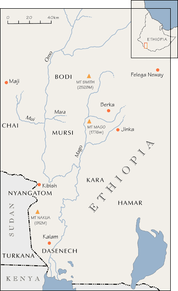
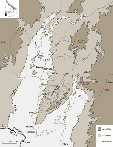
The Mursi live in a rough oblong of territory, bounded to the west and south by the River Omo, to the east by the River Mago and to the north by the River Mara (Map 2). Much of this area consists of a volcanic plain, sloping from east to west, which is being gradually lowered by the action of a large number of seasonal streams flowing westward to the River Omo and northward to the River Mago. The plain is dominated by a range of hills, running diagonally from southwest to northeast, which form a continuation of the Omo-Mago watershed and reach a height of 1,666m. in a dome-like summit, called ‘Dara’ (Map 1). The climate is semi-arid to arid, with mean annual rainfall decreasing from about 800mm to 400mm from north to south. Most of the year’s rainfall is concentrated into two short rainy spells, one between March and April (the primary maximum, or ‘big rains’, called oiyoi in Mursi) and one between October and November (the ‘small rains’, or loru).
The Omo (Warr in Mursi) is one of Ethiopia’s largest rivers. It flows south for over 1000km. from the Blue Nile and Sobat watersheds, to the northern end of Lake Turkana, on the Kenyan border. Since most of its main catchment is at heights of 2000-3000m., its level rises and falls every year in response to the rainfall regime of the Ethiopian highlands. It begins to rise in April or May and reaches its maximum level in August or September, when it overflows its banks in Mursiland and, more extensively, in its lower basin. Having reached its maximum level, the river recedes rapidly during September and October, when people start preparing the recently flooded area for flood-retreat cultivation. It is at its lowest, and easily fordable at several places, by December/January, the height of the dry season (su kiango: literally ‘the stomach of the sun’).
Vegetation in the immediate vicinity of the Omo banks varies between large forest trees, (e.g. Ficus (chamochi), Diospyros (kirithoi), Ziziphus (dangkwe), Salvadora (gegi) and Tamarindus (ragai)) and dwarf shrub grassland (e.g. Tribulus (kathogi), Solanum (turgiyai), Maerua (kamaloi), Sporobolus (keri) and Ricinus (balathi)). Further back from the east bank in the Mursi area, and decreasing in width from north to south, is a dense belt of woody plants or ‘bushland thicket’ (e.g. Euphorbia Tirucali L. (kalangarai), Sarcostemma (kirin kirini), Cissus Quadrangulsaris L (turoi), Sanseviera (kashoi), Acacia Mellifera (radi-a-kora), Adenium Obesum (dorbin) and Plectranthus (lukwe)). The bushbelt gives way abruptly, along the 500m contour, to open wooded grassland, rising gradually to the Omo-Mago watershed. Here are found, scattered or in groups, such trees as Commiphora Africana (olbai), Comiphera penduculata (lareni), Combretum (lalai), Sclerocariya (chobwe), Lannea (kiringeni) and Grewia (kalochi-a-kora).
It has been estimated that the level of Lake Turkana dropped dramatically (for a ‘non-outlet’ African lake) between the late 1890s and the 1970s, due to reduced rainfall over the Omo’s highland catchment area (Butzer, 1971). This resulted in a reduced river flow and, in some cases, the drying out of the Omo’s westward flowing tributaries, leading to the growth of woody vegetation along the Omo banks. Satellite imagery shows that the Omo delta expanded by 500 sq. km during the 1980s and 1990s, suggesting that the lake level and river flows have continued to decrease up to the present (Haack, 1996).
‘Landscape People and Parks’ Project (2007-2010)
The ‘Landscape People and Parks’ project is the first landscape-scale attempt to understand the interaction between people and the environment in the lower Omo. The project team has been inter-disciplinary, including one historian, two anthropologists and one palaeoecologist. The project ran between 2007-2010, funded by the AHRC. Research methods included the collection and analysis of oral histories of land use and settlement over the past two hundred years; a study of library and archival sources relating to the history of the lower Omo since the 1880s; a study of long term vegetation change, using fossil pollen and charcoal counting; and a study of vegetation structure and its immediate response to human action over the past forty years.
The overall aim of the project has been to reach a detailed understanding of the sequence of environmental changes and of the way these changes have influenced, and have been influenced by, the land-use practices and migratory movements of the human population.
Palaeoecological research, based on the analysis of fossilised pollen from hyrax middens in the northern part of the study area resulted in a 2000-year record of vegetation change. This is the first time such evidence of long term vegetation change in the lower Omo Valley has been obtained and the first time this particular method of obtaining fossilised pollen has been attempted in East Africa. Both the palaeoecological research and the study of bush encroachment in the savannah over the shorter term helped to demonstrate the wider relevance and value of integrating ecological and local knowledge of landscape change.
Oral history interviews carried out amongst the peoples of the study area, combined with a thorough examination of secondary sources, resulted in the most comprehensive and detailed account yet given of the complex processes of identity formation in the lower Omo over the past two hundred years.
In September 2009 the project brought together scholars from various disciplines (history, anthropology, palaeoecology and archaeology) who have worked in the lower Omo over the past forty years, for an international workshop on ‘Anthropology and History along the Omo.’ This workshop generated a series of publications in the Journal of East African Studies.
As the only source of academic research data on the history of human-environmental relations in the Lower Omo, the project has had a significant, if difficult to quantify, impact on two controversial policy debates concerning the future of river basin development in the lower Omo: the future of state-sponsored conservation and the investment in hydro-power and large-scale commercial irrigation schemes. Project members have contributed to these debates through conference papers and presentations, media interviews and frequent discussions with politicians, administrators, human rights activists and aid officials.
More information
For the analysis of a two thousand year record of vegetation change in Mursiland, obtained from a fossil hyrax midden (a method never before employed in East Africa), see Graciela Gil-Romera, Henry F. Lamb, David Turton, Miguel Sevilla-Callejo and Mohammed Umer, 'Long-term resilience, bush encroachment patterns and local knowledge in a Northeast African savanna'. Global Environmental Change, 20, 2010 pp. 612-626.
For a rare study of vegetation dynamics in the grassland plain west of the Omo (north of lat. 5 30N), see Michael J. Jacobs and Catherine A. Schloeder, ‘Fire frequency and species associations in perennial grasslands in south-west Ethiopia’, African Journal of Ecology, 40, 2002, pp. 1-9.
For a discussion of the growth of the Omo River delta, using satellite imagery, see Barry Haack, ‘Monitoring wetland changes with remote sensing: an East African example’, Environmental Management, 20:3, 1996, pp. 411-419.
For information on the geomorphology and ecology of the lower basin of the Omo see (1) Karl Butzer, Recent History of an Ethiopian Delta: the Omo River and the Level of Lake Rudolf, Research Paper 136, Department of Geography, University of Chicago, 1971; and (2) Claudia Carr, Pastoralism in Crisis: the Dassanetch and their Ethiopian Lands, Research Paper No. 180, Department of Geography, University of Chicago, 1977.